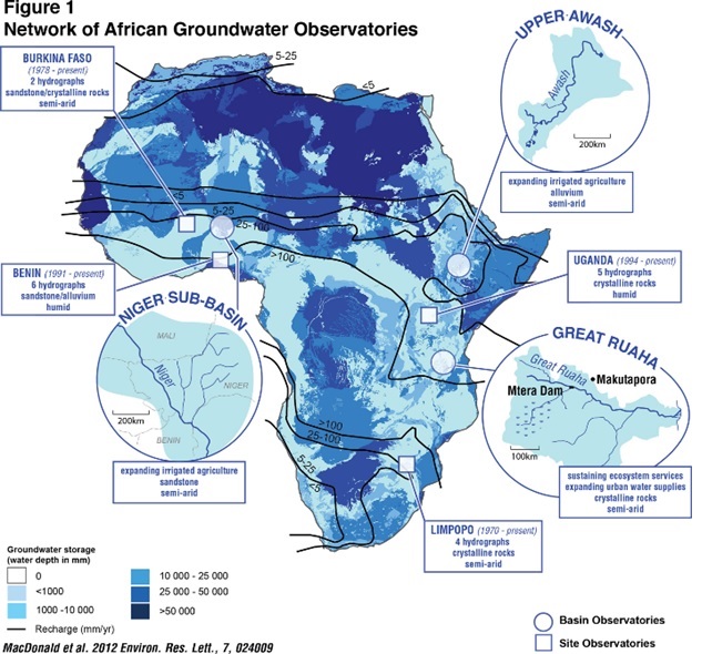
Network of African Groundwater Observatories (NAGO)
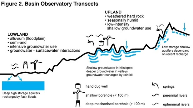
A central feature of GroFutures is the establishment of a Network of African Groundwater Observatories (NAGO) to promote collection, assimilation and use of groundwater data (Figure 1). The NAGO comprises 3 Basin Observatories in Ethiopia (Upper Awash), Niger and Nigeria (Iullemmeden), and Tanzania (Great Ruaha) along with 4 Site Observatories in Benin, Burkina Faso, South Africa and Uganda. We distinguish between Basin and Site Observatories on the basis of the type of data available and the nature of the analyses we will conduct. The NAGO will be set up to enable comparative analyses at multiple scales involving sites along topographical transects (Figure 2) that are nested within the Basin Observatories thereby providing a means to ‘scale up’ and generalise from specific sites.
Each Basin Observatory is to consist of an upland to lowland transect of dedicated groundwater monitoring stations that include nested piezometers and soil-moisture probes. In terms of hydrometeorological data, we will primarily reply upon observations from existing stations in each basin. In the Iullemmeden Basin, we will apply direct measurements of ET from existing flux towers to test the estimation of ET using conventional algorithms such as Penman-Monteith. The broad hydrological characteristics of each basin will be characterised using long-term hydrometeorological monitoring. Constructed piezometer nests and supplementary observations will enable us to tackle key science questions regarding recharge pathways (i.e. focused versus diffuse, role of soil macropores/factures) and role of extreme events (e.g. sub-daily storm events) in generating recharge. Stations will also permit us to conduct detailed site experiments that include the application of Magnetic Resonance Sounding and long-term pumping tests to quantify groundwater storage in situ and trace recharge pathways and groundwater residence times.
Research questions to be informed by the NAGO including basin observatories:
- What are the historical and event-based relationships among climate, land-use, and groundwater recharge? How sensitive is recharge to rainfall thresholds, extremes and event sequencing? What climate processes drive recharge-relevant rainfall?
- What are the characteristics and relative contributions of diffuse recharge via soil matrices and macropores/fractures, and focused recharge pathways through leakage from surface flows? To what extent is diffuse recharge controlled by the properties of the soil matrix and/or macropores?
- What is the magnitude of in situ derived groundwater storage co-efficients estimations and how do they compare to theoretical approximations currently used to define the volume of groundwater within hydrogeological environments in Sub-Saharan Africa?
- Can simple analytical models represent site observations of groundwater levels in order to quantify groundwater recharge and discharge? To what extent do current large-scale global hydrological models represent the observed timing and magnitude of recharge in Sub-Saharan Africa?